CURIOSITIES OF THE CURITY & FERRIS RAVINES
 |
| Abandoned waterworks in Ferris Ravine, May 2012 |
At this point, a word or
two should be said about the fluvial system which so far links all of
these sites: the Don River. "Don," of course, was not its
original appellation. The Anishaanabe name that the native
Mississauga people had for the Don was purportedly Wonscotanach,
said to mean either "river of the black burnt grounds"
(compare with the Kemet, or "Black Lands" of Lower
Egypt's "red kings") or "burning bright point"
(compare with the "bright" associations of clarus/Saint
Clair). Prior to the Mississaugas, Iroquois and Wyandot tribes
inhabited the region, although any names they might have had for the
Don were never recorded. This, however, did not stop surveyor
Alexander Aitkin from placing the mysterious name Ne-cheng-qua-kekonk
on some of Toronto's first city plans, without reference to any
source or possible translation.
The present "Don"
came about through some alleged resemblance to the river in
Yorkshire, England. Its name, in turn, likely derives from the common
Celtic word for any sort of river or stream (indeed, a common
Indo-European root; see Danube, Donets, Dnieper, etc.) —
although some would have it arriving from there through the
intermediary Dôn or Danu, a Celtic mother-goddess
whose own name likely descends from the aforementioned term for
running water. In Harold Bayley's 1919 treatise Archaic England:
An Essay in Deciphering Prehistory from Megalithic Monuments,
Earthworks, Customs, Coins, Place-names, and Faeric Superstitions,
such connections between toponymy and theonomy are further outlined:
In the Caucasus — the
land of the Kimbry, don was a generic term for water and for
river: we have a river Dane in Cheshire, a river Dean
in Nottinghamshire, a river Dean in Forfarshire, a river Dun
in Lincolnshire, a river Dun in Ayrshire, and a river Don
in Yorkshire, Aberdeen, and Antrim. There is a river Don in Normandy,
and elsewhere in France there is a river Madon which is suggestive of
the Madonna: the root of all these terms is seemingly Diane,
Diana, or Dione, and it may reasonably be suggested that the dene or
Dane holes of this country, like many other dens, were originally
shrines dedicated to the prehistoric Madonna.
Ptolemy's "Modonnos"
designation for the Hibernian Avoca must now raise some additional
eyebrows, all the while leaving us to guess what, if any,
implications this might have for our own Avoca pool. Furthermore,
such reference to Diana — traditionally of the pre-Roman
Italian lunar goddess Diviana, meaning "bright" or
"shining one" — piques supplemental interest by
way of the luminous St. Clair, then by dint of the white moonlight previously linked with the alchemical Red King's queen, and finally through Diana's later Roman pseudonym of
"light-bearer," or Diana Luciferia, a name which naturally led to certain conflations with Lucifer (the
shining "light-bearer" of the morning star, Venus) during
the Christian era. Indeed, to this last point, even in ancient times she was already drawing
dark associations with such company as Hecate, Greek goddess of the
dead and nocturnal witchcraft.
"Don," or
rather Donn, it must now be noted, is also the name of an Old
Irish god of death and lord of the Gaelic underworld. He is mentioned
in the tale of Dá Derga's Hostel (referred to earlier)
by a trio of "red horsemen" who "ride the steeds of
Donn," and has thus been associated with Dá Derga
himself. Donn has likewise been linked with Dagda, patriarchal god of
the Tuatha De Danann, or "tribe of Dana/Danu," the
very same goddess mentioned above; while donn is also,
according to the Dictionary of the Irish Language, another
word for "brown, apparently a light brown inclining to yellow
or red," as well as for a "chief, noble, or ruler
(poetic)," again suggesting ties with our elusive "red
king." To this end, we might recall the previously mentioned
Queen Macha Mong Ruad ("red haired"), noting how her
father, King Áed Ruad, was said to have drowned in a waterfall
known as the Ess Duinn, or "rapids of Donn," which
also brings to mind the drowning Red King of alchemical lore.
Observing one last "red king" in regards to this topic, we
should note that, following Christianization, Donn quickly
became a local byname for Satan, as well.
 |  |  |
With respect to the "dene
or Dane holes" referred to by Bayley, these are a collection
of mysterious subterranean structures, found mainly in the southeast
of England, taking the form of small limestone caves and dug-outs
entered from above by vertical shafts. Best guesses relate them to
ancient chalk mining enterprises, but nothing definitive can be said
of them for certain. In seeking local counterparts we might make
reference to the copious outfalls and manholes which tend to
accompany any urban waterway. While these, as a rule, are easily
enough explained, certain exceptional examples require further
inquiry.
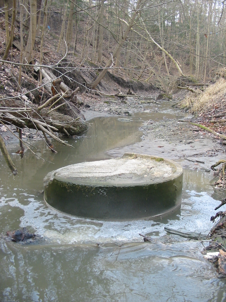
One such example in the
Curity Ravine (a sub-tributary of the Don by way of the Taylor-Massey
Creek) stands out like a bizarre reflection of the abovementioned
Avoca pool. Of comparable shape and size, this Curity "denehole"
contradicts its opposite in nearly every other aspect. Whereas the
pool affects a rough-hewn ring of rustic ashlars, the denehole
appears as a smooth circular tube of precast concrete. Whereas the
pool holds its waters surrounded by land, the denehole emerges like
an island from the middle of a stream. What connects these two
artifacts, aside from a common river system, is once again St. Clair
Avenue. This road is interrupted for a great distance by said river
system, ending just past the pool at Moore Park in the west, and
resuming just above the denehole at Parkview Hill in the east. Again,
these two features will be shown to inhabit approximately the same
rectified latitude, with Crothers Woods laying roughly equidistant
between them.
What is remarkable about
the hole, aside from its odd location, is the fact that it appears to
be purposefully, and permanently filled in — also with concrete,
though of a much coarser variety than that of the outer shaft
(compare again to the Roxborough pillars). This is perhaps somewhat
explicable given its mid-riverine position...but then, it is just
that position which makes this shaft all the more inexplicable. If
this were merely another storm sewer entrance, or some other utility
maintenance portal, one would typically expect to find it off by the
side of the stream, not directly in the midst of it. Likewise, if
this were any sort of functioning manhole one would certainly not
expect it to be sealed over so immutably. In such a state, one can
only gather that whatever it was once used for, it is no longer in
use; keeping everything outside steadfastly out (and anything inside
steadfastly in).
Making our requisite
check on toponymy, "Curity" seems to be an uncommon variant
of the Irish surname McGerrity, which the ONC has descending
by some tortuous route from the Gaelic Mag Oireachtaigh, a
noble byname meaning "son of a member of the court or assembly."
The original "member" in question here (according to such
sources Rev. Patrick Woulfe's Irish Names and Surnames, and
C. Thomas Cairney's Clans and Families of Ireland and Scotland)
was one Oireachtach Ó Roduibh, with the "court or
assembly" in question being that of the O'Connors — selfsame
clan of the "red king" Rory O'Connor whom we cited earlier
in Crothers Woods. Some coincidence, then, that this ravine just
happens to run its length alongside the area's main thoroughfare,
O'Connor Drive.
A short trip across
O'Connor Drive and we're quick to find another spur of the
Taylor-Massey Creek known as the Ferris Ravine; a soggy little trench
that runs between Ferris Road and various "Glen"-begun
addresses (Glenwood, Glencrest, Glen Gannon, Gleneden, Glenfield,
etc.). The ravine is inaccessible by any formal means — and
understandably so — being of such little conspicuity that one might
suspect it is barely noticed even by those whose properties back on
to it. Nevertheless, one can't help but detect signs of much past
(and perhaps recent) activity in this rather out-of-the-way region.
Firstly, there appears to
have been some aborted attempt at riparian plumbing during one, if
not multiple phases of the ravine's history, with decaying segments
of concrete and metal piping strewn about the streambed in every
direction. Of much greater intrigue, though, are a series of
enigmatic markers placed in some of the most remote sections of this
already remote location: an old broom, stuck upright into the ground
just west of Rexleigh Drive; what appears to be a shovel (or other
such implement), plunged downwards into the ground and framed by a
primitive niche of branches, just east of Rexleigh Drive; then a
makeshift footbridge and four wooden stakes, driven into the ground
right where the stream flows under this very street.
 |  |  |
Rexleigh Drive is
significant in that it divides the Ferris Ravine roughly in two; and
while the western half runs in more-or-less straightforward solitude
towards the Taylor Creek, the eastern half abruptly forks around Glen
Robert Drive, with the southern prong continuing on as far as
Cedarcrest Boulevard, and the northern prong terminating just below
the oft-recurring St. Clair Avenue. If we now follow this northward
fork the whole of its brief span, two additional objects of note
should catch the observant eye: a pair of manholes, not covered as
per usual, nor indefinitely closed-off like the Curity hole, but with
their lids left invitingly ajar. Nothing in their proximity would
indicate the presence of "men at work," nor indeed of
anyone having recently been at their location. Still, their expectant
condition would tend to suggest they were, at least at one time, the
site of frequent visitation.
What, then, are we to
gather from this strange assortment? The open manholes, one could
assume, somehow relate to the abandoned waterworks project further
downstream. But what of those bizarre markers which seem to serve no
discernable utility? For what purpose, and for what audience could
these curiosities be intended, withdrawn as they are, quite in the
middle of nowhere?
Well the broom, to begin
with, being an obvious symbol of cleansing, has long served as a
fetish for warding off evil — especially when placed with bristles
up, typically near a doorway or other entrance to whatever area is
being protected. Conversely, its other main association has
historically been with witchcraft, and prior to roughly the late 15th
century witches were just as likely to be depicted astride a shovel,
hoe, or pitchfork as on a broomstick — perhaps suggesting some
thaumaturgical connection to the handle further upstream. Most
curious of the three marking sites, however, are the quartet of
wooden stakes and the little bridge by the culvert heading under
Rexleigh Drive. The paltry span and terminal location of this meagre
bit of stream certainly requires no bridge to negotiate it; whereas
the stakes, all gathered as they are directly at one end, would make
it un-crossable in any event (hearkening somewhat to the impassable
gateway of Beaumont Road). We must, therefor, assume either some
ornamental, ceremonial, or symbolic function for this odd
installation...but, again, to what purpose?
Resorting once more to
toponymical insight, we have in "Rexleigh," as we did with
Craigleigh earlier, another macaronic hybrid — only now the Old
English leigh, or "meadow," is adjoined with
the Latinate rex which, of course, refers to a "king."
If we were again to employ the same Irish-izing trick, turning leigh
into lea, we would now have a "grey king" to go
along with the "red king" of Crothers Woods — but we
would also still be left with a hybrid, and thus little reason for
taking such liberties. In "Ferris," however, the concept of
some kind of powerful Celtic figure is again reinforced, for that is
precisely what the name implies, being a variant of the Gaelic
Fergus, itself a compound of fear "man" +
ghus "strength." If we now continue to pursue the
previous line of thought regarding rex we will uncover the
Gaulish/Proto-Celtic word rix, of the same root and meaning,
and found in the names of such historic chieftains as Dumnorix,
Ambiorix, and Vercingetorix. Analysis of two other aforementioned
names reveals Glen "Gannon" to be from the Gaelic fionn,
or "white," and Glen "Robert" to be from the
Germanic hrod "fame" + berht "bright"
— and yet once more we are met with ties (however loose) to
previously examined names, and possible
associations with some luminous figure, event, or phenomena.
Among the few local
street names made protrusive by their lack of a "Glen-"
prefix, just north of the ravine we have "Hale" Court, from
an Old English word of the same lineage as "hole," used as
a topographic name for someone who lived in or by a nook, hollow, or other
such recess (a denehole, perhaps?); and "Leander" Court,
named apparently after the figure from Greek mythology who drowned in
the Hellespont while attempting a swim to his paramour (refer, once again, to such drownings before). Both of these cul-de-sacs extend from a Stag Hill
Drive, and, in keeping with these mythic overtones, one now recalls
the stag to be a symbol of many mythic characters: be they Cernunnos,
the ancient antlered fertility god of Celtic tradition; or Cocidius
the Romano-British hunter god (whose name may relate in some way to
our "red king" via the Brittonic root-word cocco,
"red"); or yet another victim of Grecian tragedy, the
unfortunate Actaeon, who was turned into a stag, then set upon by his
own hounds, after stumbling upon the goddess Artemis while bathing
(the stag being a symbol of hers as well). This tale, in fact, has
something of a reverse-counterpart in the Irish legend of Ossian,
whose very name translates as "young stag" due to the fact
that his mother, Sadhbh, was returned to human form from that of a
deer by his father Fionn (see "Gannon" above).
At this juncture, what
further thought are we to give to the fact that Artemis is the Greek
equivalent of the Roman goddess Diana, whose name we've already seen
related to the Don River through Harold Bayley's "prehistoric
Madonna" — and then what of the Greek Dodona, first
among the Hellenic oracles, whose magic spring and holy grove is
thought consecrated to an ancient, unknown mother-goddess; or even
the so-called "Celtic Mercury" (recalling again the alchemical White Queen) so often depicted alongside a stag in
ancient relief, and most prominently so at the French mountain shrine
of Le Donon? Let us simply end our discussion of this site
here, with two more rather glaringly-named streets (which, while not directly abutting the Ferris Ravine, do intersect with Ferris
Road just to the south) — namely Ravenwood Place and Druid Court —
toponyms requiring, by now, little explication; with the former being
presaged by the Roxborough ruins, and the latter being
somewhat tacitly implied all throughout these investigations.