TODMORDEN ALIGNMENT
Along the Todmorden Mills
stretch of the Don River, nestled into a wedge of infrastructure
formed by the CPR Don Valley rail bridge and the DVP/Bayview
Extension interchange, one will find the site in question. This
particular ruin, it should be said, is not of the concrete variety,
but rather of that other "compatible" material which
constitutes our locally preferred reinforced compound: steel.
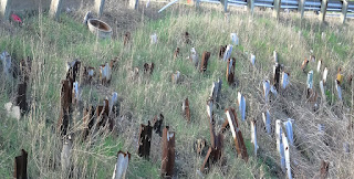
Nevertheless, this is, perhaps, Toronto's most unusual ruined site,
for here, overlooking the river from a steep embankment, hundreds of
metal highway barriers have been stuck into the ground for,
seemingly, no apparent reason.
The overall impression
one gets from this oddity is decidedly megalithic, with the site
spread out like a miniature Carnac, running roughly 100 meters along
the incline with its corrugated menhirs placed haphazardly
throughout; all thrust into the earth at various depths and angles,
some standing vertically, 2 to 3 feet high, others barely breaking
the surface of the soil, or jutting perpendicular from the hillside.
As such, the other impression one is likely to get from this site is
that of a mass of toppled grave markers in some long abandoned burial
ground. Of course, the location and materials involved would tend to
preclude any such fanciful interpretations, but if we look to the
relevant toponymy, one can't help but be struck by certain curious
correlations.
"Todmorden," to
begin with, harkens to a village in northern England straddling the
traditional border between Yorkshire and Lancashire, just as the
present Todmorden Mills sits in the historic borderlands between the
old township of East York and the old city of Toronto. The ultimate
origin of this name is somewhat obscure. The Oxford Names
Companion has it fittingly translated as "boundary valley
of a man called Totta" (tracing back from the earlier
Tottemerden, an apparent construct of the Old English Totta
+ maere + denu). However, a persistent folk etymology
would have the translation coming closer to something like "a
woods" or "valley of death," taking the first two
syllables from separate linguistic strains to express the same morbid
concept twice (Germanic/Old English todt/toth + the
Latin/Old French mort). In fact, this theory finds some
support in the existence of a local feature known variously as
Blackheath Circle, Blackheath Barrow, or Roman Barrow — another
megalithic site in the form of an ancient ring cairn which, by all
archaeological accounts, served as the venue for sundry prehistoric
funerary rites (interestingly, this cairn also seems to be unique in
its isolation from any other known ritual sites or settlements of
like vintage in the area). Meanwhile, our local Todmorden's deathly
connotations are vaguely bolstered by the adjacent commencement of
Mortimer Avenue — a name of probable Norman French ancestry,
combining morte + mer to equal "dead water"
or "waters of death" — and how strangely synchronous that
we should have this potentially fatal site right next to a major
river.
Of course, this is all
highly conjectural, if not flatly coincidental. "Todmorden"
was merely the home village of one of the mill's proprietors, most
will argue. "Mortimer" was simply the name of some early
settler, local land owner, or other notable resident. But then
there's still the ruins. How to account for them? And how to account
for all the others we have yet to define? It's hard to say. But let
us attempt to account for as much as we can, and begin our
investigations in earnest by putting this conjectural approach into
practice just a little further to the north.


